Elevate Your Designs: The Ultimate Guide to Aerial Rendering Techniques

3D agora
March 4th, 2024
Understanding aerial rendering is key for anyone in architecture, real estate, or urban planning. These visualizations offer a comprehensive view of how projects integrate with their surroundings, crystallizing future developments in detailed imagery. This article breaks down the process behind aerial rendering, its strategic advantages for stakeholders, and the technologies shaping its evolution, without overwhelming technical jargon.
Elevating Your Project's Appeal with Aerial Renderings
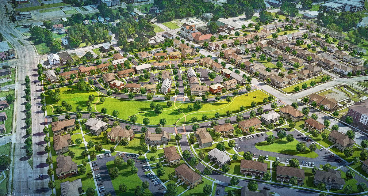
 Created by Kirk Fromm
The allure of aerial renderings lies in their ability to:
Transform the mundane into the extraordinary
Present architectural projects from an elevated viewpoint
Encapsulate the essence of design
Merge the detailed intricacies of a structure with the breadth of its surroundings
Enhance visual appeal
Forge an emotional connection
Allow viewers to experience the envisioned space in its entirety, long before it materializes into reality.
Aerial renderings, including aerial and drone renderings, are more than just a visual treat; they are a strategic asset in the competitive realm of property marketing. These high-quality images serve as a beacon, guiding the decisions of investors and distinguishing properties in the marketplace. Through the lens of aerial 3D rendering, every landscape design feature, architectural nuance, and the project’s integration with its environment are displayed with unprecedented clarity, making aerial view rendering an essential tool in property marketing.
The Power of Perspective: Bird's Eye View in Modern Design
The bird’s eye view is not merely a camera angle; it’s a storytelling device that reveals the grand scale and full narrative of an architectural project. From the rooftop terraces to the meticulous layout of rooms, aerial renderings offer a unique perspective that ground-level shots cannot capture, providing a comprehensive view that is essential for both architects and stakeholders. These renderings allow for an exploration of design concepts and scenarios, enhancing the visual impact and aiding in the identification of potential design flaws.
Yet, the power of these renderings extends beyond aesthetics. The ability to zoom in and analyze specific sections without losing the overarching context ensures that every design choice is made with full knowledge of its visual and functional implications. The realism achieved through meticulous attention to detail, such as the accurate representation of materials and vegetation, furthers the persuasive narrative of architectural aerial renderings. This clarity and depth of detail ensure that stakeholders are fully informed and supportive of the project direction.
Visualizing the Future Building: Before Construction Begins
The true magic of aerial architectural renderings unfolds in their capacity to envision the future. They serve as a crystal ball, revealing the transformation of spaces and offering a glimpse of the completed structure amidst its actual environment before construction commences. This foresight is not just a visual spectacle but a tactical maneuver that gives developers an edge, attracting new clients and securing investments with the promise of what’s to come.
By bridging the gap between imagination and tangible reality, aerial renderings become the cornerstone of effective communication. They translate architectural visions and intricate project details into a language that everyone, from clients to urban planners, can understand and appreciate. This visual dialogue, initiated before the first brick is laid, builds anticipation and confidence, ensuring the project resonates with its intended audience.
Crafting High-Quality Aerial Scenes: Techniques Behind the Imagery
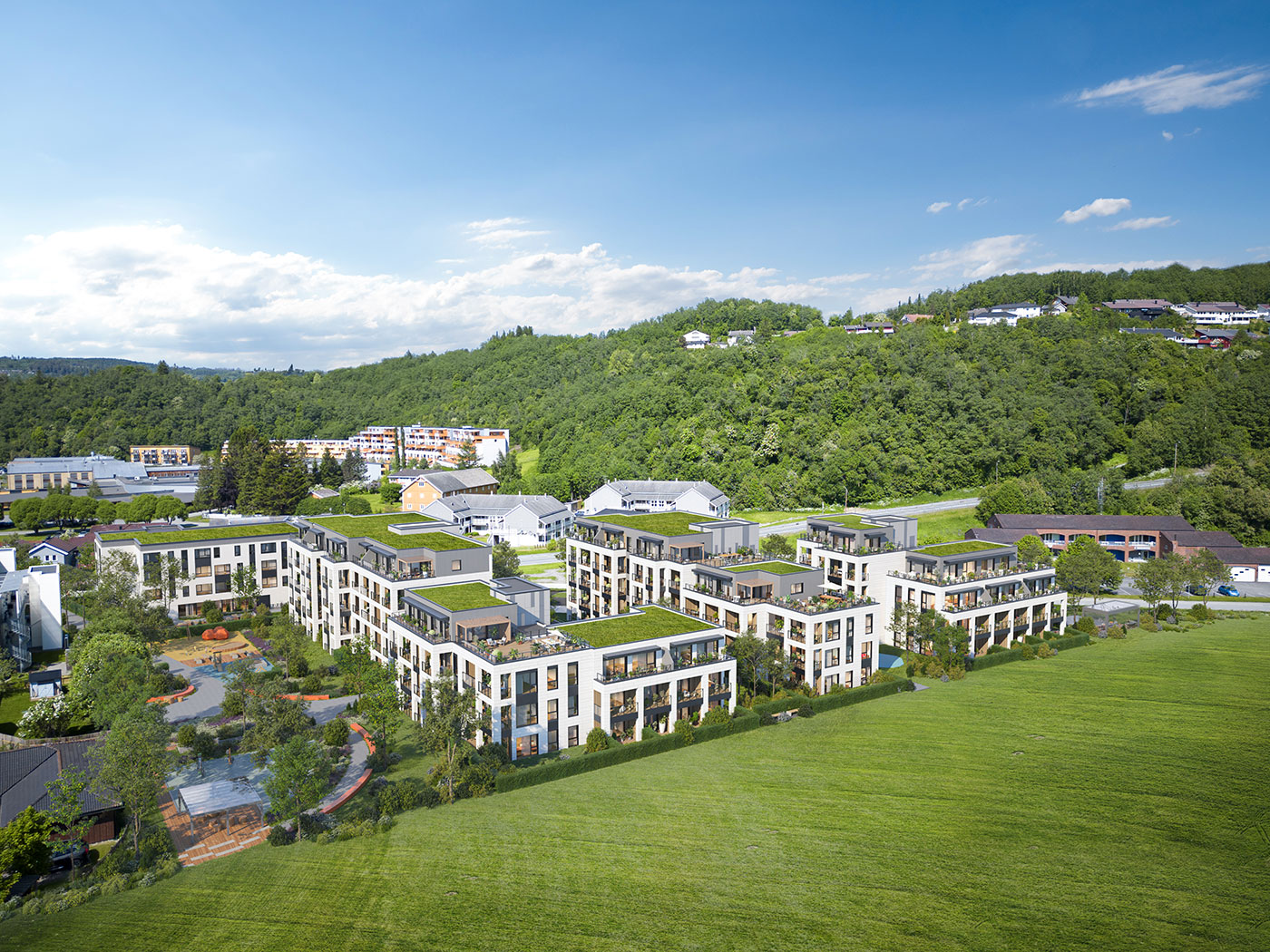
 Generated by SurferAI
The creation of mesmerizing aerial scenes is an art form underpinned by a suite of techniques designed to captivate and inform. The process begins with selecting the right camera angle, which sets the stage for how the viewer will interact with the property. Whether it’s a broad panoramic or a focused straight-on view, each angle serves to highlight the architectural features and create a striking visual impact. The composition, too, plays a pivotal role, utilizing principles such as the Rule of Thirds and Leading Lines to guide the viewer’s gaze and narrate the property’s story.
Lighting and texture are the subtle yet powerful brushes with which aerial scenes are painted. They shape the visual appeal and credibility of the final renderings, enveloping the viewer in a scene that feels both inviting and authentic. Post-processing is the final touch, refining textures and enhancing colors to ensure that the imagery not only reflects the project’s vision but also leaves a lasting impression on the viewer. By defining the rendering style at the onset, whether aiming for photorealism or a stylized interpretation, the aerial perspective is brought to life, simulating atmospheric conditions that add depth and dimension to the scene.
Achieving Realism: Natural Elements and Lighting in Aerial 3D Rendering
The quest for a realistic representation in aerial 3D rendering is a pursuit of the perfect harmony between natural elements and lighting. Trees, water bodies, and lush vegetation are not mere embellishments; they provide context, scale, and a sense of the actual environment within which the project sits. Lighting, with its transformative power, can evoke emotions and set the scene’s mood, from the warmth of a sunset to the coolness of a shadowed façade, compelling the viewer to connect with the space on an emotional level.
Atmosphere plays a critical role in the authenticity of aerial renderings. Techniques such as scattering, which mimics the natural light diffusion in the air, provide depth and a realistic aerial perspective. Furthermore, environmental impacts like shadow patterns and wind flows can be visualized, aiding sustainable design decisions that resonate with the mindful considerations of modern architecture.
From Drone Snapshots to Final Renderings: Blending Photography with 3D Models
The synthesis of drone photography and 3D modeling is a revolutionary stride in the evolution of aerial renderings. Drones have democratized access to aerial views, providing accurate topography mapping essential for anchoring architectural models in their true context. This fusion of reality and digital artistry allows designers to situate their creations within an accurate environment, marrying the precision of drone imagery with the imagination of 3D modeling.
Photogrammetry stands at the heart of this integration, creating detailed maps that not only enrich the visual experience but also serve to identify potential design conflicts early in the development process. CG artists employ tracking techniques to ensure that 3D models seamlessly align with the perspectives captured by drones, resulting in final renderings that are indistinguishable from the real world. This meticulous blending process is crucial for creating aerial imagery that is as informative as it is stunning.
Showcasing the Surroundings: The Role of Aerial Views in Property Marketing
 Created by Arqsix
The role of aerial views in property marketing cannot be overstated; they are the visual storytellers that highlight the unique selling points of a property. These high-resolution images capture features such as intricate landscaping and rooftop patios, which may be overlooked from street level but become defining elements when seen from above. The essence of residential or commercial spaces is communicated through these aerial visuals, which articulate the property’s connectivity to its surroundings, including access to transport and proximity to other buildings.
Properties, regardless of their setting, benefit from the expansive narrative provided by aerial renderings. Whether it’s a suburban home’s spacious layout or a waterfront property’s exclusive access to natural amenities, aerial imagery conveys the tranquility, functionality, and allure of the location. This aerial perspective is essential for real estate developers and marketers, as it offers a comprehensive view of the property’s surroundings that ground level shots simply cannot match.
Capturing the Vibe: Conveying Atmosphere Through Aerial Visuals
Aerial visuals are more than just images; they are the canvas on which the vibe and atmosphere of a project are painted. Daytime and nighttime lighting conditions have the power to transform the perception of a space, illustrating how it functions and feels under different lighting scenarios. These conditions not only affect the aesthetic appeal but also influence the emotional response of the viewer, making the choice of camera angle - whether an intimate eye-level shot or a sweeping high-angle view - a critical component in the storytelling process.
The atmosphere conveyed through these visuals can be as varied as the projects themselves, from the serene ambiance of a natural landscape to the buzzing energy of an urban development. By strategically manipulating natural lighting and camera positions, aerial renderings capture the essence of a property’s surroundings, enhancing marketing efforts and ensuring that the visual impact resonates with prospective buyers.
The Workflow of Aerial Rendering Services
The workflow of aerial rendering services is a meticulously orchestrated process that transforms client visions into stunning aerial visuals, including aerial scene rendering. It begins with an in-depth consultation, where project requirements are discussed, and a wealth of reference materials such as blueprints and photographs are gathered to ensure the rendering is true to the actual site.
The creation of a 3D model lays the groundwork, setting the stage for the aerial view that will encapsulate the client’s style preferences and effectively convey the story of the project. As the rendering takes shape, drafts are shared with the client, who provides feedback to refine the imagery until it aligns perfectly with their expectations.
Upon final approval, the detailed and polished aerial rendering is delivered, ready to dazzle in marketing materials, client presentations, or as part of the documentation required for development approvals.
Navigating Client Expectations: Communication and Collaboration
Clear communication and collaboration are the backbone of any successful aerial rendering project. Establishing realistic timelines and maintaining an open dialogue ensures that client expectations are in sync with the capabilities of the aerial rendering services. Progress reports and regular updates keep clients engaged, allowing them to witness their project’s evolution from concept to high-resolution rendering.
Transparency regarding the possibilities and limitations of aerial rendering technology is crucial, as it builds trust and sets the stage for achievable outcomes. By involving clients from the outset, major setbacks are avoided, and the design process becomes a collaborative effort that benefits from the insights of all parties involved.
Presenting clients with multiple design options through 3D visualization ensures they can make informed decisions, confidently selecting their preferred design based on clear visual comparisons.
Leveraging New Technology: Advancements in Aerial Rendering Tools
The landscape of aerial rendering is continuously reshaped by technological advancements, with interactive aerial rendering standing at the forefront of this evolution. This dynamic form of rendering offers:
Real-time exploration
Immersive experience
Enriched understanding of the project
User control of navigation
Detailed view of how the architectural project impacts the surrounding landscape
These new technologies not only facilitate a more interactive visualization experience but also streamline client collaboration. Real-time platforms enable immediate visual feedback and adjustments, ensuring that aerial renderings are tailored to the client’s precise specifications and that the final result is a true representation of their vision.
Integrating Aerial Renderings Into Urban Planning
 Created by Arqsix
The integration of aerial renderings into urban planning represents a paradigm shift in how complex projects are visualized and communicated. These renderings provide stakeholders with a clear and detailed view of how a project fits within its urban context, offering insights into land use, connectivity, and sustainability considerations. Urban planners leverage aerial perspectives to visualize the intricate relationship between new developments, traffic flow, pedestrian pathways, and the environmental impact, facilitating informed decision-making.
By incorporating accurate data from GIS and satellite imagery, aerial renderings become a powerful tool for modeling various urban scenarios. This integration allows for the design of sustainable urban environments that balance aesthetic appeal with functional efficiency. Aerial visuals enhance the urban design process, enabling planners to better understand spatial arrangements and the interplay between different urban elements, ultimately leading to a more cohesive and well-thought-out cityscape.
Contextual Clarity: Understanding Projects Within Their Environment
The bird’s eye view renderings offer:
An unparalleled understanding of a project’s size, scale, and relationship with its environment
A vantage point that reveals the intricate interplay between the constructed space and the surrounding buildings and landscape
An unmatched level of contextual clarity
Indispensable information for urban planners to predict the outcome of various development scenarios and ensure sustainable and visually harmonious city layouts.
The inclusion of natural elements and the accurate portrayal of the surrounding terrain in aerial renderings add a layer of depth and realism, allowing for a comprehensive understanding of the project’s true scale. Video walkthroughs, often created using these renderings, extend this context further by showcasing not just the property itself but also nearby amenities and points of interest, thus enhancing the marketing and analysis processes and aiding in efficient land-use analysis.
Informing Infrastructure Decisions: Visualizing the Project's Infrastructure
Aerial renderings shine a spotlight on infrastructure, providing a bird’s eye view that can inform and expedite decision-making. These renderings reveal:
How new developments will transform spaces
How they will integrate with existing transportation networks
Potential design flaws that can be avoided
Cost savings that can be achieved
Stakeholders gain the ability to visualize and assess the project’s infrastructure, ensuring that the development adheres to urban planning guidelines and contributes positively to the community.
Advancements in data gathering, such as GIS and LiDAR technology, have enhanced the precision of aerial renderings. The integration of AI further augments this accuracy, ensuring that every road, pathway, and landscaping element is depicted with meticulous detail. This level of visualization supports informed decision-making, helping planners and developers to align their projects with the long-term objectives of urban development.
Enhancing Client Presentations: The Benefits of Aerial Architectural Renderings
 Created by Arqsix
Aerial architectural renderings are transformative when it comes to client presentations, providing vivid and accurate representations of the final project. These renderings are a formidable tool that aids clients in visualizing the full potential of the design, transcending the limitations of imagination or 2D diagrams. They serve as an essential bridge between concept and reality, delivering a comprehensive visual package that effectively communicates the project’s appeal.
The ability to guide presentations with artistic aerial renders cannot be undervalued. These renderings serve as inspirational images, influencing investment decisions and contributing significantly to the success of architectural projects. Moreover, the use of realistic and flattering lighting within these renders is critical; it instills confidence in the materials presented, as exaggerated or improperly rendered lighting can lead to skepticism among potential buyers.
Setting the Scene: Aerial Renderings as Inspirational Images
Aerial renderings are not just tools for visualization but also sources of inspiration, setting the scene for what could be. They provide high-quality images that engage potential clients or investors, giving them a clear and impressive image of the project, and often serve as the catalyst for the emotional connection required to move forward with a deal. The ability of these renderings to convey concepts, atmospheres, and emotions is invaluable, particularly when traditional drawings or verbal descriptions might fall short.
The use of aerial 3D imagery has become increasingly sophisticated, with virtual reality technologies providing immersive experiences that bring proposed designs to life. This level of interactivity and visualization facilitates communication among stakeholders, ensuring that the final renderings align with the design concept and marketing strategies.
Beyond the Blueprint: Aerial Renderings as a Reference Material
Aerial renderings offer several benefits for architectural projects:
They provide comprehensive reference materials that showcase a project from multiple perspectives.
They bring the finer details of a building project to life, allowing for a clear presentation of complex architectural designs.
By providing a zoomed-out view, they capture the entirety of a project, enabling viewers to visualize and understand the design in a way that is both intuitive and detailed.
These versatile renderings are not just static images; they are living documents that adapt and evolve, providing a reference that can be revisited throughout the development process. They serve as a constant source of guidance and clarification, ensuring that the project’s vision is maintained from the initial design phase through to completion.
Summary
Aerial renderings are a nexus where technology, creativity, and strategic marketing converge to redefine the presentation and planning of architectural projects. From crafting realistic scenes and showcasing the surroundings to enhancing client presentations and supporting urban planning, these renderings offer invaluable insights and visual storytelling prowess. As we’ve seen, the ability to visualize the future through aerial perspectives is more than a luxury; it’s a necessity that empowers architects, planners, and developers to achieve their vision with precision and impact.